

History of Batanes
The Spanish Dominican friars attempted to Christianize the Ivatans as early as 1686 but the efforts were abandoned with the death of two resident missionaries. In 1718, the missionaries made another attempt to bring the people of Batanes under the Cross.
It was to the credit of Governor Jose Basco y Vargas that the island were finally brought under the Spanish Crown in 1782. Batanes was annexed to the colony on the following year. The islands were constituted into a separate province but it was later downgraded to the status of a town and attached to the province of Cagayan. The islands regained the status as a province in 1855 but was again reduced to a dependency of Cagayan in 1900 when the Americans took control of the islands. In 1909 by virtue of Act 1952, Batanes was again established as a separate province.
Please read more on the below link:
******************************************************
Taiwan (newspaper) claim on our Batanes island
In the year 2007 the Taipeh Times newspaper published an article by a Taiwanese university professor Chen Hurng-yu 陳鴻瑜 about the island of Batanes which he claims that Batanes is not a part of the territories ceded by Spain to the United States in the 1899 Treaty of Paris ending the Spanish-American War.
Manila's weak claim to the Batanes - by Chen Hurng-yu
***********************************
The claim of Taiwan to our Batanes Islands was due to Taiwan wrong interpretation of the confusing wordings in the territorial boundary in the Treaty of Paris between Spain and the U.S.A. However there were many written records about the Spaniards settling and controlling the islands of Batanes since the year 1600s. According to International Law an effective and continous occupation of a territory is one of requirement of sovereignty, reference the Island of Palmas Case.
http://www.haguejusticeportal.net/index.php?id=5184
Since Batanes islands was governed by Spain with continous and effective occupation which was continued by the succeeding American government and later the Philippines, under the International Law our Batanes island is a part of the Philippines, eventhough it was not included in the 1899 Treaty of Paris between Spain and the United States of America.
Furthermore in the 1895 Treaty between Spain and Japan which is controlling the island of Formosa / Taiwan, the mentioned treaty specified that the demarcation line between Japan and Spain is the Bashi Channel which is located in the parallel of Latitude 21 degrees 30 minutes North.
Related topics related to continous and peaceful display of sovereignty which is related to
Batanes Islands.
The Hague Justice Portal - The Island of Palmas Case (or Miangas) Award
http://www.haguejusticeportal.net/index.php?id=5184
https://inside.law.umn.edu/uploads/cb/04/cb04edc11f6929954501aeb5430d654b/Handout-Island-of-Palmas-for-Osofsky-Property-Spring-2013.pdf
Palmas Island now renamed Pulo Miangas
http://jibraelangel2blog.blogspot.jp/2011/05/palmas-island-now-renamed-miangas-one.html
*******************************************
Copy of the Treaty of Peace Between the United States and Spain; December 10, 1898
The United States of America and Her Majesty the Queen Regent of Spain, in the name of her august son Don Alfonso XIII, desiring to end the state of war now existing between the two countries, have for that purpose appointed as plenipotentiaries:
The President of the United States, William R. Day, Cushman K. Davis, William P. Frye, George Gray, and Whitelaw Reid, citizens of the United States;
And Her Majesty the Queen Regent of Spain,
Don Eugenio Montero Rios, president of the senate, Don Buenaventura de Abarzuza, senator of the Kingdom and ex-minister of the Crown; Don Jose de Garnica, deputy of the Cortes and associate justice of the supreme court; Don Wenceslao Ramirez de Villa-Urrutia, envoy extraordinary and minister plenipotentiary at Brussels, and Don Rafael Cerero, general of division;
Who, having assembled in Paris, and having exchanged their full powers, which were found to be in due and proper form, have, after discussion of the matters before them, agreed upon the following articles:
Article I.
Spain relinquishes all claim of sovereignty over and title to Cuba.And as the island is, upon its evacuation by Spain, to be occupied by the United States, the United States will, so long as such occupation shall last, assume and discharge the obligations that may under international law result from the fact of its occupation, for the protection of life and property.
Article II.
Spain cedes to the United States the island of Porto Rico and other islands now under Spanish sovereignty in the West Indies, and the island of Guam in the Marianas or Ladrones.
Article III.
Spain cedes to the United States the archipelago known as the Philippine Islands, and comprehending the islands lying within the following line:
A line running from west to east along or near the twentieth parallel of north latitude, and through the middle of the navigable channel of Bachi, from the one hundred and eighteenth (118th) to the one hundred and twenty-seventh (127th) degree meridian of longitude east of Greenwich, thence along the one hundred and twenty seventh (127th) degree meridian of longitude east of Greenwich to the parallel of four degrees and forty five minutes (4 [degree symbol] 45']) north latitude, thence along the parallel of four degrees and forty five minutes (4 [degree symbol] 45') north latitude to its intersection with the meridian of longitude one hundred and nineteen degrees and thirty five minutes (119 [degree symbol] 35') east of Greenwich, thence along the meridian of longitude one hundred and nineteen degrees and thirty five minutes (119 [degree symbol] 35') east of Greenwich to the parallel of latitude seven degrees and forty minutes (7 [degree symbol] 40') north, thence along the parallel of latitude of seven degrees and forty minutes (7 [degree symbol] 40') north to its intersection with the one hundred and sixteenth (116th) degree meridian of longitude east of Greenwich, thence by a direct line to the intersection of the tenth (10th) degree parallel of north latitude with the one hundred and eighteenth (118th) degree meridian of longitude east of Greenwich, and thence along the one hundred and eighteenth (118th) degree meridian of longitude east of Greenwich to the point of beginning.The United States will pay to Spain the sum of twenty million dollars ($20,000,000) within three months after the exchange of the ratifications of the present treaty.
http://avalon.law.yale.edu/19th_century/sp1898.asp#art3
( You can enlarge the images / photos by double clicking it )
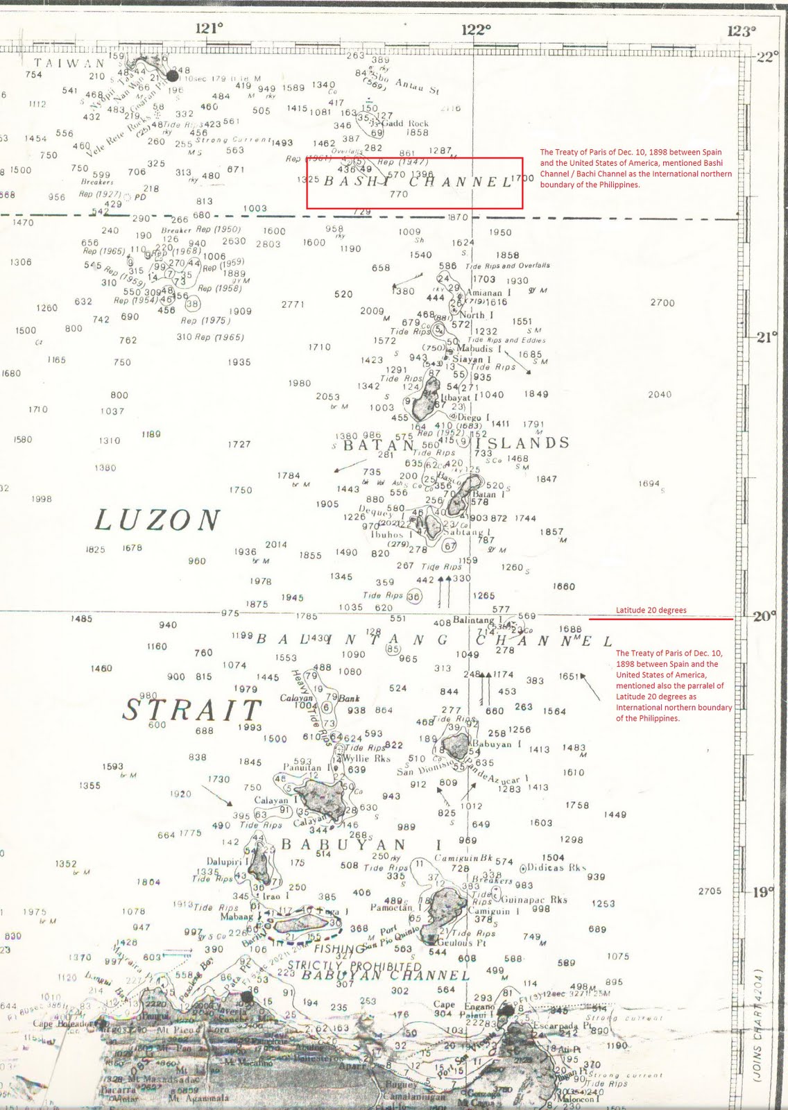
The mentioned Treaty of Peace between Spain and the U.S. is mentioning Bashi Channel located in
Latitude 21 degrees - 25 minutes North, as the northern boundary of the Philippines.
However the same Treaty mentioned also mentioned Latitude 20 degrees - 00 minutes North, which is located in Balintang Channel as the northern boundary of the Philippines.

************************************************
A Primer on Philippine Territorial Claims
by Manuel L. Quezon III, mlquezon3@gmail.com
In recent weeks, the Spratlys have been in the news, and questions raised about the rather mysterious policy of the Philippine government as far as explorations for oil and gas in cooperation with Vietnam and China, which have competing claims to territory the Philippines claims sovereignty over. Every president has found it advantageous to assert Philippine claims to territory. One such president was Diosdado Macapagal, whose first claim to national fame was in 1948, when he raised the Philippine flag in the Turtle Islands.
I recently asked a visiting Spanish historian what the Spaniards considered the Philippines during the colonial era. His answer, which he sketched on a map, would surprise you. He said that for the Spaniards, the Philippines covered, a vast area extending from what present-day Filipinos consider the Philippines, but stretching as far as Guam and Saipan in the Marianas and the Caroline Islands. This territory is commemorated to this day by one of the obscure titles of the King of Spain, Rey de las Islas del Poniente.
Up to 1815, the Philippines were considered, essentially, an extension of the Viceroyalty of Mexico, and after Mexican independence from Spain, we were a province directly governed from Madrid.
Manila, in turn, after 1815, had jurisdiction over the Marianas and the Carolines. Guam, in the Marianas, was the place that Spain exiled troublesome Filipinos, for example, like Tandang Sora. According to the Spanish historian, the Northern Marianas had, as its last governor, a Filipino-born Spaniard, Eugenio Blanco, who suppressed a local rebellion by means of volunteer troops from Macabebe, Pampanga, in a ferocious campaign called “El Tiempo del Macabebe” in the literature of the era.
What seems to have happened, when Spain was defeated by the US in the Spanish-American War, was that the Americans only expressed interest in only part of the colonial real estate of Spain. And so, in the Treaty of Paris in 1898, what Spain ceded to America was the Philippines and the Marianas, while America allowed Spain to retain the Carolines. The Carolines, in turn, were sold by Spain to Germany in 1899. The Spanish historian said that the sale was contested in the Cortes by a friend of Rizal.
Now as for Filipinos, our own conception of what constituted the Philippines was limited compared to the Spanish view. It’s commemorated in our flag: the rays of the sun representing the nucleus of our independent state, the eight provinces placed under martial law when our revolution began in August, 1896.
And the three stars representing the territorial aspirations of our founding fathers: Luzon, the Visayas, and Mindanao. The efforts of our first Republic in 1898 were to assert the sovereignty of the First Republic over these areas. And they ranged from successfully encouraging the Federal Republic of the Visayas based in Iloilo to recognize the Republic, which it did, and the Sultan of Sulu to incorporate his realm into our Republic, which was less successful. But aside from the Sulu Sultanate, from the start, our Republic claimed the rest of Mindanao, over which Spain had already asserted its sovereignty.
Going back to the Treaty of Paris, the territory ceded by Spain became the working definition for our country, as it prepared for the restoration of independence by 1946. However, the delegates to the Constitutional Convention that drafted our 1935 Constitution noticed some problems.
Part of the Constitutional Convention’s published records, includes a report signed by Nicolas Buendia, former senator (and yes, of Buendia Avenue fame), who was Chairman of the Committee on Territorial Delimitation. He said that if you look at the Batanes Islands, the limit of our territory in that area should be the Bashi Channel.
But the Treaty of Paris, according to Buendia’s committee report, was based on erroneous Spanish maps used in a 1895 agreement between Spain and Japan, which then owned Tiawan, and so the quoted lines of latitude and longitude in Spain’s agreement with the US placed the border at the Balintang Channel. Buendia recommended that the Philippines, in its new Constitution, fix the error so as to remove all room for doubt.
But it seems the report wasn’t adopted in full, because instead of adopting the technically complete list of revised latitudes and longitudes, the 1935 Constitution was quite brief: the Philippines was the territory ceded by Spain to America in 1898 plus the Turtle Islands as agreed upon by Britain and the US in 1930.
Our legislator failed to correct the geographical coordinates of the boundary between Taiwan and the Philippines according to the Treaty of Washington of 1900 which amended the Treaty of Paris of 1898.
But it seems the report wasn’t adopted in full, because instead of adopting the technically complete list of revised latitudes and longitudes, the 1935 Constitution was quite brief: the Philippines was the territory ceded by Spain to America in 1898 plus the Turtle Islands as agreed upon by Britain and the US in 1930.
* * * * * * *
Our legislator failed to correct the geographical coordinates of the boundary between Taiwan and the Philippines according to the Treaty of Washington of 1900 which amended the Treaty of Paris of 1898.
"Treaty Between the Kingdom of Spain and the United States of America for Cession of Outlying Islands of the Philippines - 1900"
SOLE ARTICLE
Spain relinquishes to the United States all title and claim of title, which she may have had at the time of the conclusion of the Treaty of Peace of Paris, to any and all islands belonging to the Philippine Archipelago, lying outside the lines described in Article III of that Treaty and particularly to the islands of Cagayan, Sulu and Sibutu and their dependencies, and agrees that all such islands shall be comprehended in the cession of the Archipelago as fully as if they had been expressly included within those lines.
The United States, in consideration of this relinquishment, will pay to Spain the sum of one hundred thousand dollars ($100,000) within six months after the exchange of the ratifications of the present treaty.
* * * * * * *
The result is that, to this day, Taiwan questions our border with it in the Bashi Channel. However, to their credit, what the Taiwanese want is an international agreement to settle the border question. At least the question of the Turtle Islands was explicitly referred to in the 1935 Charter.
Which brings us back to Diosdado Macapagal and his finally raising the Philippine flag on the Turtle Islands in 1948, or 18 years after the treaty signed by the US and Great Britain recognizing them as part of our territory. But as for other territory, dealing with a new country and not the US, the British would be quite cunning, indeed.
As we prepared to rejoin the family of independent nations in 1946, Great Britain made moves to take the North Borneo territory leased by the Sultan of Sulu to a private company, under its own authority. What was land leased to the British North Borneo Company was declared crown territory instead. If the Philippines could claim to be the successor, as sovereign, of territories once owned by the Sulu Sultanate, by the late 1950s the future Malaysia was preparing to assert sovereignty over territories once ruled by Great Britain in its colony of Malaya.
To be sure, we’d first asserted our claims to North Borneo in 1946, under the advice of former Governor-General Francis Burton Harrison, working as an adviser to our new Department of Foreign Affairs. A Foreign Office spokesman said it was rather cheeky of the newly independent Philippines to do this.
But it was Diosdado Macapagal of Turtle Islands fame, who most vigorously asserted our claim to North Borneo, or Sabah as we call it, to the extent that he broke off diplomatic relations with newly independent Malaysia and formed an alliance with Indonesia, pursuing its own quarrels at the time with Malaysia.
President Marcos went beyond asserting the claim.
http://archive.arabnews.com/?page=7§ion=0&article=107756&d=12&m=3&y=2008
**************************************
Related Web Link :
Our Exotic Batanes Islands province
Taiwan claim on our Batanes island.
http://www.timawa.net/forum/index.php?PHPSESSID=n6u6se91528gl63d1hv4k58fr6&topic=23396.0
No comments:
Post a Comment