

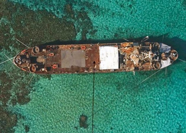
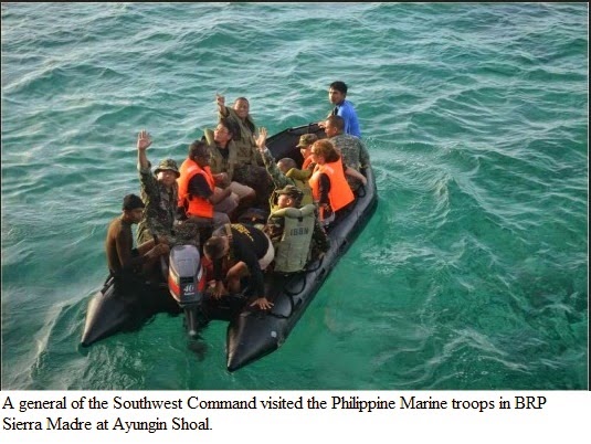
BRP Sierra Madre at Ayungin Shoal


Below remarks were quoted from the article of Mr. Jose Antonio A. Custodio, a security and defense consultant and was a technical adviser for a US defense company working for the US Pacific Command. He also specializes in military history and has post-graduate studies in history from the University of the Philippines. He also teaches history and political science at several universities in Metro Manila.)
If China manages to secure Ayungin Shoal, it will be a dagger
pointed at both the garrisons at the KIG and at military and civilian
installations at Palawan itself.
The construction of a Chinese garrison at Ayungin will provide them
with a means to effectively restrict Philippine vessels to Palawan’s immediate
coasts and interfere with freedom of navigation there as Beijing will naturally
project 200 nautical miles from it toward the Philippines as part of its own definition
of an Exclusive Economic Zone (EEZ).
Ayungin Shoal should be seen by the Philippines as the proverbial
line in the sand.
There should be no retreat. Ayungin must not be given up as
it will lead to making the Kalayaan Island Group untenable.
Doing so will also
lead to demoralization in the Philippine military and subsequent loss of
national will to defend if the government continues to resort to withdrawing in
the face of Chinese pressure.
Ayungin Shoal also known as Second Thomas Shoal is an uninhabited shoal in the Spratly / Kalayaan
Islands Group in the West Philippine sea, 105 nautical mies (194 km; 121 miles) west of Palawan.
Located just southeast of Mischief Reef, at Latitude 09 44 00N Longitude 115 52 00E. Second Thomas Shoal / Ayungin Shoal is the gateway to Reed Bank near Palawan coast which is rich in natural gas. It is a tear-drop shaped atoll, 11 miles (18 km long) and fringed with coral reefs. The coral rim surrounds a lagoon which has depths of up to 27 meters and is accessible to small boats from the East. Drying patches are found east and west of the reef rim.
Ayungin shoal (Second Thomas Shoal) is inside the Philippine's 200miles Exclusive Economic Zone (EEZ) however it is also claimed by China since it is inside the China's ridiculous Nine Dash Line or Ten Dash line, which encompasses nearly the whole South China / West Philippines Sea till the coast of Luzon, Palawan, and Sabah.
The new Chinese map, which was first published on January 2013 by China's state mapping authority Sinomap Press, features 10 dash lines instead of nine dash lines to mark a huge swath of the South China Sea in a tongue-shaped encirclement as Chinese territory.
The Philippine Navy maintains a presence of less than a dozen navy personel on a rusting ship. The 100 meters long US built (Second World War) Philippine Navy ship BRP Sierra Madre was deliberately run aground at Ayungin Shoal (Second Thomas Shoal) in 1999 in response to the Chinese occupation of Mischief reef. Ayungin shoal lies within the Philippine's 200 nautical miles (320 km) Exclusive Economic Zone.
http://en.wikipedia.org/wiki/Second_Thomas_Shoal
****************************************************
Securing the Shoals, What must be done.


Dozens of Filipino moderate left activists protested Wednesday at China's consulate in Manila to protest a dangerous attempt by Chinese coast guard ships to block a Philippine supply boat near a disputed shoal in the South China Sea.


You Tube Videos of Ayungin Shoal
China's Ten-dash line
Related story :
Securing the Shoals, What must be done.
http://www.interaksyon.com/article/67903/securing-the-shoals--what-must-be-done
Akbayan pickets China consular office over Ayungin harassment http://www.interaksyon.com/article/83978/photo--akbayan-pickets-china-consular-office-over-ayungin-harassment
US accuses China of provoking Philippines in South China Sea standoff
Imminent invasion of our Kalayaan Islands Group by China
http://jibraelangel2blog.blogspot.jp/2014/01/imminent-invasion-of-our-kalayaan.html
China's aggression in Scarborough Shoal
Nine-dotted line http://en.wikipedia.org/wiki/Nine-dotted_line#History
China's new '10-dash line map' eats into Philippine territory
Ayungin Dilemma
Ang Islang Kinamkam ng Tsina
Refuting
China’s Nine-Dash Claim