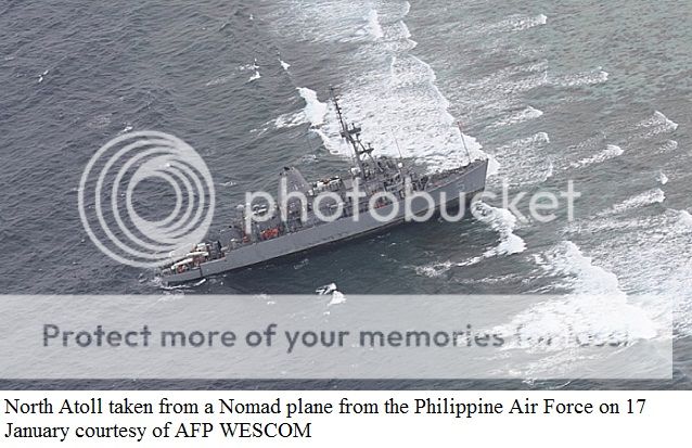
The agrounding of USS Guardian (MCM 5) a US Navy Avenger-class mine countermeasures ship.
.jpg)


USS
Guardian Grounding Investigation To Include Faulty Chart
Data
PEARL HARBOR, Hawaii -
A U.S.
Navy investigation to assess the circumstances surrounding the USS Guardian
(MCM 5) grounding that occurred in Philippine waters will include information
on faulty digital navigation chart data that misplaced the location of
Tubbataha Reef.
On Friday, the U.S. National Geospatial-Intelligence Agency
(NGA) provided the Navy preliminary findings of a review on Digital Nautical
Charts (DNC) that contain inaccurate navigation data and may have been a factor
in the Guardian grounding that occurred in the Sulu Sea on Jan. 17 Philippine
time.
**************************************************************************
My own personal opinion regarding the agrounding of USS Guardian
Last January 17th a US Navy minesweeper vessel named
"USS Guardian" was agrounded in Tubbataha Reef Marine Park a
UNESCO-protected Marine sanctuary.
The ship had arrived at the former US naval base in Subic
Bay in Olongapo City on Jan. 13 for a routine resupply, refueling and rest and
recreation stop and a quick visit to Puerto Princesa before sailing off to
its next destination of Timor Leste near Indonesia.
In my opinion the agrounding of USS
Guardian was another incident of ECDIS-assisted agrounding. ECDIS means
Electronic Chart Display Information System now used and compulsary in some
type of Commercial ships plying the international voyage.
There were many instances of commercial ships agrounded
because of the malfunctioning of ECDIS.
Below were the web links regarding the ECDIS-assisted
agrounding of vessels.
In the commercial vessels we use the term ECDIS and in the
US Navy, I presume they used the word
DNC or Digital Navigational Chart where paper Charts/Maps
were replaced by Digital Charts.

An
Electronic Chart Display and Information System (ECDIS) is a
computer-based navigation information system that complies with
International Maritime
Organization
(IMO) regulations and can be used as an alternative to paper nautical charts. IMO refers to similar systems not meeting
the regulations as Electronic Chart
Systems
(ECS).
An ECDIS system
displays the information from electronic navigational charts (ENC) or Digital Nautical Charts (DNC) and
integrates position information from position, heading and speed through water
reference systems and optionally other navigational sensors. Other sensors
which could interface with an ECDIS are radar, Navtex, automatic identification
systems
(AIS), Sailing Directions and fathometer.

Since
the USS Guardian was enroute to Indonesia after making port calls in Subic Bay and Puerto
Princesa in Palawan, most probably they will pass through Basilan
Strait. From Puerto Primcesa to Basilan strait is nearly straight course passing
on the edge of Tubbataha Reef.

*************************************
RELATED YOUTUBE VIDEOS OF THE
AGROUNDING:
USS
Guardian , ilang beses daw sinabihan ng Phl Coast Guard na
huwag
pumasok sa Tubbataha
Reef
USS
Guardian pinasok ng tubig matapos sumadsad sa Tubbataha
Reef
Militants Storms US Embassy
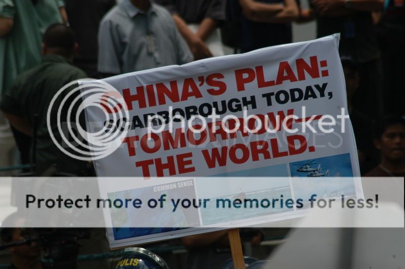
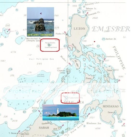
I am just wondering why the leftist movement of BAYAN did not protest when the Chinese annexed our Panganiban Reef in 1994, did not protest when the PRC Chinese Navy agrounded their Naval ship in Half Moon shoal - Hasa Hasa Shoal last July 2012 and when the PRC Chinese neo-colonialist occupied our Bajo de Masinloc / Scarborough Shoal.
USS Guardian tinatanggalan na ng Krudo
UNTV News: Salvage operation sa USS Guardian, natapos na (APR012013
***********************************************
Related Story :
Photos of Tubbataha Reefs Natural Park -
Cagayancillo, Palawan
***************************************************************
Related news on the agrounding of USS Guardian.
Philippine govt urges US to save reef, not ship
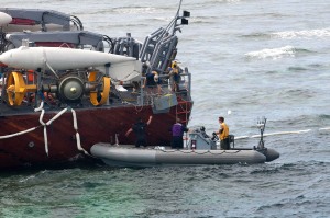
The United States Navy has sent 10 American divers to assess the situation and brought in two private salvor ships to try to extricate its minesweeper that got stuck on Tubbataha Reef, a world-renowned marine sanctuary in the Sulu Sea, the Philippine Navy said yesterday.
Environmentalists have expressed worry the extraction may damage the reef more. Palawan Governor Abraham Mitra called on Philippine authorities to take charge of the operation so that priority could be given to saving the coral reef rather than the US ship.
“The reef (a heritage site) should be the priority not the ship. They can always build a new boat but it takes a lifetime for the reef to recover. As a responsible country, the US should exert all efforts in reef rehab and conservation efforts as millions of fishermen rely on it to feed their fishing grounds in the surrounding areas. We should take the lead and not allow the US to call the shots,” said Mitra.
Stranded US Navy ship ignored warnings: Philippines
US Navy minesweeper that has been stuck on a World Heritage-listed coral reef in the Philippines since last week ignored warnings to avoid the area, a government official said on Monday.
The comments from the superintendent of Tubbataha marine park, Angelique Songco, added to growing anger in the Philippines over the incident, for which the US Navy has apologised but may still face fines.
Park rangers radioed the USS Guardian to advise it was nearing the Tubbataha Reef on Thursday, but the ship captain insisted they raise their complaint with the US embassy, Songco told reporters.
She said shortly after the warning, the 68-metre (224-foot) vessel became stuck on part of Tubbataha Reef, a UNESCO World Heritage Site on the Sulu Sea about 130 kilometres (80 miles) southeast of the western island of Palawan.
US Navy to be charged with unauthorized entry, damage to Tubbataha Reef
The Tubbataha Protected Area Management Board (TPAMB) on Tuesday disclosed that it will charge the United States Navy with unauthorized entry and damage to Tubbataha Reef after its warship, the USS Guardian, ran aground on the UNESCO-declared world heritage site's pristine coral atoll.
“Under Republic Act 10067, it is the TPAMB is mandate to protect, preserve and promote the resources of Tubbataha Reef… It is the TPAMB’s intention to serve the US Navy with a formal notice listing violations of the above law in the grounding incident of January 17 involving the USS Guardian,” the park management said in a statement. http://tubbatahareef.org/news/624
US ship to be lifted by crane from Tubbataha reef
http://www.rappler.com/nation/20346-us-ship-to-be-lifted-by-crane-from-tubbataha-reef


http://gmanetwork.com/news/story/297348/news/nation/tubbataha-caretaker-reveals-major-progress-in-uss-guardian-salvage-ops?ref=related_stories
‘USS Guardian’ Navigator Misplaced Tubbataha by 8 Nautical Miles – US
http://ph.news.yahoo.com/uss-guardian-navigator-misplaced-tubbataha-8-nautical-miles-173333387.html
Navy removes harmful material from Gounded USS Guardian
January 28, 2013
From U.S. 7th Fleet Public Affairs
Navy removes harmful material from Gounded USS Guardian
January 28, 2013
From U.S. 7th Fleet Public Affairs
SULU SEA – A team of U.S. Navy salvage experts have been meticulously scouring the damaged USS Guardian (MCM 5), safely transferring anything deemed potentially harmful to prepare the grounded ship to be removed from Tubbataha Reef.

The Navy has safely transferred approximately 15,000 gallons of diesel fuel; 671 gallons of lubricating oil; dry food stores; paints and solvents contained in storage lockers; and the personal effects left behind by the crew from the ship.
“We continue to place extra scrutiny on removing everything we can to mitigate possible damage to the marine environment,” said Rear Adm. Tom Carney, the on-scene commander of the salvage operation.
USS Guardian to be dismantled, but may further damage Tubbataha
After wrestling with various other options, the US Navy has announced that it has no other choice but to dismantle the minesweeping vessel that has been stranded on Tubbataha Reef since January 17, according Defense News, a news site about the US military.
The US Navy had been preparing to lift the entire ship with giant floating cranes to deeper water or onto another ship. But the close proximity of salvage ships to the reef for the lifting operation would pose a greater risk to the reef, the US Navy has determined.
“Our only supportable option is to dismantle the damaged ship and remove it in sections,” Capt. Darryn James, spokesman for the U.S. Pacific Fleet, told Defense News on Tuesday.
Lessons from the USS Guardian grounding... Don't trust Charts
With a US Navy investigation underway to assess the circumstances surrounding the USS Guardian grounding that occurred in Philippine waters at 02.25 on 17 January local time there are lessons already to be learned: Charts are not infallible even if they are on screen and it is not wise to navigate to fine tolerances with the aid of GPS when the underlying data is less accurate than the GPS.
An inaccurate chart is not a defence – not bumping into bits of ground remains the master’s responsibility.
Much of the Philippine waters have not be surveyed for 50 years or more, an issue highlighted when the Greenpeace ship Rainbow Warrior also grounded on Tubbataha Reef in 2005. The chart in use showed the reef 1.5 miles from where it actually was.
The digital chart aboard USS Guardian, an Avenger-class mine countermeasures vessel, showed a position about eight nautical miles in error. At the time of the grounding the vessel was attempting passage through a channel just half that width.
NAMRIA tells Maritime Accident Casebook that the last hydrographic and topographic survey covering Tubbataha Reef was conducted in 2006 using single beam echosounder for the hydrographic data, 2008 is the latest hydrographic survey using multibeam echosounders. The chart was first published last May 2009 and the reef is marked as a restricted area on current charts.
On Friday, 18 January, the US National Geospatial-Intelligence Agency, NGA provided the US Navy with preliminary findings of a review on Digital Nautical Charts (DNC) that contain inaccurate navigation data and may have been a factor in the Guardian grounding.
This followed the realisation by NGA that there might be a potential inaccuracy regarding the Tubbataha Reef digital chart. NGA has reviewed data from more than 150,000 square nautical miles in the surrounding area and found no additional errors.
Tubbataha caretaker reveals 'major progress' in USS Guardian salvage ops

"Good weather this week has allowed significant progress to be made in salvaging the USS Guardian, which has been grounded on Tubbataha Reefs since January 17, 2013," it said.
Inclement weather conditions last week had endangered the safety of the salvage crews and forced a delay in the salvage operations.
Inclement weather conditions last week had endangered the safety of the salvage crews and forced a delay in the salvage operations.
USS Guardian ran aground at Tubbataha Reef last Jan. 17, and TMO officials estimate it may have damaged 4,000 square meters of the reef.
The TMO said the USS Guardian's weather deck was completely cleared last Feb. 27.

Also, the funnel and mast had been dismantled while navigational equipment and controls were removed.
"The salvage team is now working on the second level of the US minesweeper and will then conduct diving operations to inspect the submerged section of its hull," the TMO said
******************************************************
Photos on the dismantling USS Guardian at Tubbataha Reef


US Navy ship removed from Philippine reef
Salvage teams on Saturday removed the last piece of a US Navy ship that was stuck on a UNESCO World Heritage-listed coral reef in the Philippines for more than 10 weeks, the coast guard said.
The stern of the USS Guardian was lifted off the Tubbataha Reef after the 68-metre (223-foot) vessel was sliced into portions for easier removal, Philippine coast guard spokeswoman Lieutenant Greanata Jude said.
Bad weather had earlier delayed the recovery operations but once the skies cleared, a salvage ship used a huge crane to lift the bow, the deck, the funnel and other pieces of the ship off the reef.
"The salvage ship will still remain in the area. After the lifting, they will clear the area of debris. It will take three days maximum," Jude told AFP.
The minesweeper ran aground on Tubbataha in a remote part of the Sulu Sea on January 17, damaging a section of the reef, a UNESCO World Heritage site known for its rich marine life.
The incident sparked widespread condemnation across the Philippines, a former US colony.
The US government has apologised for the accident, which it initially blamed on faulty maps. The Philippines said it would impose fines.
Due to fears that towing it to deeper waters would inflict more damage on the reef, the US government agreed to scrap and dismantle the Guardian, which was worth about $277 million.
A team from the Philippine government and major universities has already been assembled to assess the damage caused when the ship ran aground, said Tubbataha Reef marine park superintendent Angelique Songco.
Under Philippine law, ships that run aground on Tubbataha are fined 24,000 pesos ($585) for every square metre of damaged reef, she said.
She said the area of the reef damaged by the USS Guardian has been initially estimated at 4,000 square metres (43,055 square feet) but the assessment team will still check this.
"We will inspect the total damage to establish exactly what they have to pay," Songco said.
****************************************
US Navy replaces four over Philippines reef grounding
The commanding officer and three crew of a US minesweeper which ran aground on a protected coral reef in the Philippines have been relieved of their duties, the US Navy said Thursday.
A statement from the US Pacific Fleet in Hawaii said an initial investigation had found that the commander of the USS Guardian and three others had failed to "adhere to standard US Navy navigation procedures."
"The US Navy has the highest accountability standards and all four sailors were relieved by Rear Admiral Jeffrey Harley due to their role in the grounding and a loss of confidence," a statement said.
The minesweeper ran aground on Tubbataha in a remote part of the Sulu Sea on January 17, damaging a section of the reef, a UNESCO World Heritage site known for its rich marine life.
The incident sparked widespread condemnation across the Philippines, a former US colony.
The US government has apologized for the accident, which it initially blamed on faulty maps. The Philippines has said it would impose fines.
http://ph.news.yahoo.com/us-navy-replaces-four-over-philippines-reef-grounding-185953509.html
*******************
US vows full payment for Philippine reef damage
Manila (Philippine Daily Inquirer/ANN)
-
US Secretary of State John Kerry has restated his government's regrets over the grounding of a US Navy warship on the protected Tubbataha Reefs and assured the Philippines of full cooperation in the investigation of the incident.
Kerry has also assured the Philippines of full compensation for the damage caused by the grounding of the USS Guardian on the marine sanctuary in a remote corner of the Sulu Sea.
The new US secretary of state gave the assurances to the Philippines during his meeting with Foreign Secretary Albert del Rosario in Washington on Tuesday.
Del Rosario also assured the Filipino public that "every effort will be made to obtain proper compensation" for the damage to Tubbataha, initially estimated to be at around 4,000 square metres.
The two countries are conducting separate investigations of the incident. A team of investigators from the Philippine Coast Guard is flying to Japan "to examine documentary and physical evidence as well as meet with the US investigating team," Del Rosario said.
http://ph.news.yahoo.com/us-vows-full-payment-philippine-reef-damage-035001117.html
*********************************
Tubbataha was off by 8 miles on USS Guardian's digital charts, says US mapping agency
By: Priam Nepomuceno, Philippine News Agency
August 15, 2013 7:06 AM
Manila, Philippines -
Now it can be told.
Crewmen of the USS Guardian relied on inaccurate digital maps that misplaced the protected reef by as much as 8 miles, a letter by the US Geospatial Intelligence Agency to the US Navy says.
Crewmen of the USS Guardian relied on inaccurate digital maps that misplaced the protected reef by as much as 8 miles, a letter by the US Geospatial Intelligence Agency to the US Navy says.
US National Geospatial-Intelligence Agency (NGA) director Letitia Long admitted this in a letter to US Navy Chief of Naval Operations Admiral Jonathan Greenert.
She added that the DNC display of the Tubbataha Reef in the Sulu Sea was wrong due to erroneous commercial satellite imagery. Long, in her letter to Greenert, said NGA discovered that the charts related to the Tubbataha Reef prior to 2008 included a number of “phantom islands.”
To correct this problem, she said the NGA used commercial satellite imagery to update the charts.
“One of these images included incorrect information about the location of the section of ocean that includes the Tubbataha Reef. As a result, the reef was incorrectly placed in the [digital nautical chart],” Long said.
In 2011, NGA obtained survey data that corrected this positioning, but due to a failure to follow established procedure, this correction was made in one portion of the DNC, but not in another, Long said, a mistake she attributed to human error.
Long stressed that the error was compounded by “exclusive reliance” of the USS Guardian crew on GPS as a “single source of navigation.”
The crew did not pay heed to lighthouses on the reef, according to a 160-page post-wreck investigation report by Admiral Cecil D. Haney, commander of US Pacific Fleet.
The US Navy report said the grounding and destruction of the minesweeper also highlighted “potential systemic issues” on ships that use the Navy’s computer-based vessel management system and its electronic chart and display system.
The vessel management system is supposed to issue audible alerts of potential dangers, but as the USS Guardian neared the Tubbataha Reef before grounding, the Navy report said watchstanders on the bridge and in the combat information center did not report any alarms.
As the ship neared the reef, personnel on the bridge reported flashes from a lighthouse, but those were ignored as the crew continued to rely on the electronic charts and GPS.
Investigators blamed the grounding primarily on the crew’s failure to reconcile the differences between digital nautical charts of the area and more refined coastal charts.
The crew also failed to verify the position of the reef using a list of lighthouses.
The grounding broke the ship’s keel when rocks on the reef punched holes in its hull. The crew abandoned ship, with no loss of life.
“USS Guardian leadership and watch teams failed to adhere to prudent, safe, and sound navigation principles, which would have alerted them to approaching dangers with sufficient time to take mitigating action,” Haney said.
http://www.interaksyon.com/article/68643/tubbataha-was-off-by-8-miles-on-uss-guardians-digital-charts-says-us-mapping-agency
**************************************************
Related postings about other foreign incursion in Tubbataha Reef :
Chinese embassy protests arrest of poachers in Tubbataha
Chinese poachers using Hasahasa Shoal as transit point for PH sea turtles?
Chinese poachers illegally enter Philippine waters and engaged in poaching marine species in the UNESCO-protected Tubbataha Reef Marine Park a sanctuary for marine species.
The life that thrives within and around Tubbataha Reef is so precious to the Philippines and to the entire world, that its conservation is no longer a choice but an imperative".
* * * * * *
PH receives
P87M payment from US for Tubbataha Reef damage
February 18,
2015 (updated)
For the damage caused to Tubbataha Reef by the grounding of a United States Navy ship two years ago, the Philippines received P87,033,570.71 from the US government as compensation.
In a statement issued on Wednesday, the Department of Foreign Affairs (DFA) reported that the Philippine government received the full requested amount on January 30.
According to the DFA, the compensation will be utilized for the protection and rehabilitation of Tubbataha Reef Natural Park, a United Nations Educational, Scientific and Cultural Organization World Heritage Site.
“Portions of the fund will also be used to further enhance capability to monitor the area and prevent similar incidents in the future,” it said.
In addition to the compensation received, the DFA said the US government is also providing additional assistance to the Philippine Coast Guard to upgrade the PCG Substation in Tubbataha.
Read more at http://www.mb.com.ph/us-receives-87m-payment-from-us-for-tubbataha-reef-damage/#b4K5rV6qlgPmfJmt.99
In a statement issued on Wednesday, the Department of Foreign Affairs (DFA) reported that the Philippine government received the full requested amount on January 30.
“Portions of the fund will also be used to further enhance capability to monitor the area and prevent similar incidents in the future,” it said.
Read more at http://www.mb.com.ph/us-receives-87m-payment-from-us-for-tubbataha-reef-damage/#b4K5rV6qlgPmfJmt.99

.jpg)